
Bus route 47 in Birmingham goes from “Carrs Lane” to “Elliot Gardens”.
The route of bus 47
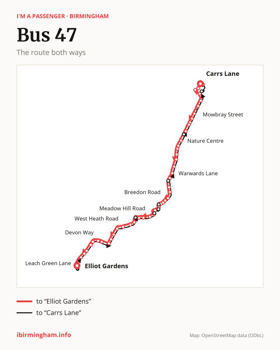
From “Carrs Lane” to “Elliot Gardens”: 50 stops. On the way: “Bus Mall”, “New Street Station”, “Old Repertory Theatre”, “Bromsgrove Street”, “Lower Essex Street”, “Mowbray Street”, “Bellevue”, “Speedwell Road”, “Edward Road”, “Calthorpe Court”. Then “Priory Road”, “Nature Centre”, “Upland Road”, “First Avenue”, “Kensington Road”, “Kitchener Road”, “Dogpool Lane”, “Warwards Lane”, “Umberslade Road”, “Hazelwell Street”. Then “Elm Tree Road”, “Fordhouse Lane”, “Breedon Cross Bridge”, “Breedon Road”, “Midland Road”, “Watford Road”, “Kings Norton Station”, “Station Road”, “Westhill Road”, “Meadow Hill Road”. Then “Nortune Close”, “St Thomas Aquinas School”, “Popes Lane”, “Oddingley Road”, “Seven Acres Road”, “West Heath Road”, “Moorpark Road”, “Clunbury Road”, “Turves Green Boys’ School”, “Culmington Road”. Before “Elliot Gardens”: “Longbridge Station”, “Devon Way”, “South and City College”, “Longbridge Island”, “Tinmeadow Crescent”, “Low Hill Lane”, “Edgewood Road”, “Leach Green Lane”.
The return journey is different. Towards “Carrs Lane”: 50 stops. Only in this direction does it call at, among others, “Hare & Hounds”, “Wychall Farm School”, “Kings Norton Park”, “Camp Lane”, “Cotteridge Island” and “Bournville Lane”. Only in the direction of “Elliot Gardens” does it call at, among others, “Bus Mall”, “New Street Station”, “Old Repertory Theatre”, “Hazelwell Street”, “Watford Road” and “Westhill Road”. For the way back, board nearby: “Bus Mall” → “Carrs Lane” (150 m), “New Street Station” → “Markets” (250 m), “Old Repertory Theatre” → “Bromsgrove Street” (350 m) and “Hazelwell Street” → “Bournville Lane” (50 m). Towards “Elliot Gardens”, board nearby: “Hare & Hounds” → “Leach Green Lane” (50 m), “Wychall Farm School” → “Popes Lane” (50 m), “Kings Norton Park” → “Westhill Road” (100 m) and “Camp Lane” → “Kings Norton Station” (100 m).
Left column runs down, right column runs up. Filled stops are served both ways, dashed ones only one way: 8 towards “Elliot Gardens” and 8 the other way. Tap a stop to see its name.
Other routes along the way
Shared sections with other routes: between “Carrs Lane” and “Kings Norton Station” it shares the road with route 45; between “Longbridge Station” and “Leach Green Lane” it shares the road with route 19; between “South and City College” and “Leach Green Lane” it shares the road with route X20.
Connections by stop, in route order:
- “Carrs Lane”: buses 2, 4A, 5, 6, 14, 16, 16A, 17, 17A, 23, 24, 33, 50, 51, 60, 61, 63, 65, 66, 67, 68, 74, 80, 82, 87, 94, 95, 97, 97A, 907, 936, 937, 997, 998, FD, X1, X2, X4, X5, X12, X14, X15, X21, X22, X51 and X64
- “Bus Mall” (only towards “Elliot Gardens”): buses 2, 4A, 5, 6, 14, 16, 16A, 17, 17A, 23, 24, 33, 50, 51, 60, 61, 63, 65, 66, 67, 68, 82, 87, 94, 95, 97, 97A, 907, 936, 937, 997, 998, FD, X1, X2, X4, X5, X12, X14, X15, X21, X22, X51 and X64
- “New Street Station” (only towards “Elliot Gardens”): buses 2, 4A, 5, 6, 16, 16A, 17, 17A, 23, 24, 50, 60, 61, 63, 80, 82, 87, 97, 97A, FD, X1, X2, X21 and X22
- “Old Repertory Theatre” (only towards “Elliot Gardens”): buses 16, 16A, 23, 24, 61, 63, 80, 82, 87, X21 and X22
- “Bromsgrove Street”: buses 2, 4A, 5, 6, 16, 16A, 17, 17A, 23, 24, 50, 60, 61, 63, 80, 82, 87, 97, 97A, X1, X2, X21 and X22
- Stops from “Mowbray Street” to “Edward Road”: buses 61 and 63
- “Calthorpe Court”: buses 1, 41, 61 and 63
- “Priory Road”: buses 1, 41, 61 and 63
- “Nature Centre”: buses 41, 61 and 63
- “Kitchener Road”: bus 76
- “Dogpool Lane”: bus 76
- “Warwards Lane”: buses 27 and 76
- “Umberslade Road”: bus 27
- “Hazelwell Street” (only towards “Elliot Gardens”): bus 27
- Stops from “Elm Tree Road” to “Breedon Road”: bus 11A
- “Midland Road”: buses 11A and 18
- “Watford Road” (only towards “Elliot Gardens”): buses 11A and 18
- “Kings Norton Station”: buses 11A and 18
- “Station Road”: bus 18
- “Westhill Road” (only towards “Elliot Gardens”): bus 18
- Stops from “West Heath Road” to “Turves Green Boys’ School”: bus 48
- “Longbridge Station”: buses 39 and 39A
- “Devon Way”: buses 39, 39A and 63
- “South and City College” (only towards “Elliot Gardens”): buses 39, 39A and 63
- “Longbridge Island”: bus 63
- “Kings Norton Park” (only towards “Carrs Lane”): bus 18
- “Camp Lane” (only towards “Carrs Lane”): bus 18
- “Cotteridge Island” (only towards “Carrs Lane”): buses 11A and 18
- “Bournville Lane” (only towards “Carrs Lane”): bus 27
- “South Drive” (only towards “Carrs Lane”): buses 1, 41, 61 and 63
- “Markets” (only towards “Carrs Lane”): buses 2, 4A, 5, 6, 16, 16A, 17, 17A, 23, 24, 50, 60, 61, 63, 80, 82, 87, 97, 97A, X1, X2, X21 and X22
Pages for these routes: bus FD, bus X12, bus X14, bus X15, bus X2, bus X20, bus X21, bus X22, bus X4, bus X5, bus X64, bus 1, bus 2, bus 4A, bus 5, bus 6, bus 14, bus 16, bus 16A, bus 17, bus 17A, bus 18, bus 19, bus 23, bus 24, bus 27, bus 33, bus 39, bus 39A, bus 41, bus 45, bus 48, bus 50, bus 51, bus 60, bus 61, bus 63, bus 65, bus 66, bus 67, bus 68, bus 74, bus 76, bus 80, bus 82, bus 87, bus 94, bus 95, bus 97, bus 97A, bus 907, bus 936, bus 937, bus 997, bus 998.
Passes and concessions
Tickets, passes and concessions are covered on a separate page: how to pay for public transport in Birmingham.
Questions about bus 47
Does bus 47 go to “Kings Norton Station”?
Yes, in both directions.
Where can I change from bus 47 to another bus route?
Most routes stop at “Carrs Lane” (2, 4A, 5, 6, 14, 16, 16A, 17, 17A, 23, 24, 33, 50, 51, 60, 61, 63, 65, 66, 67, 68, 74, 80, 82, 87, 94, 95, 97, 97A, 907, 936, 937, 997, 998, FD, X1, X2, X4, X5, X12, X14, X15, X21, X22, X51 and X64) and “Bus Mall” (only towards “Elliot Gardens”; 2, 4A, 5, 6, 14, 16, 16A, 17, 17A, 23, 24, 33, 50, 51, 60, 61, 63, 65, 66, 67, 68, 82, 87, 94, 95, 97, 97A, 907, 936, 937, 997, 998, FD, X1, X2, X4, X5, X12, X14, X15, X21, X22, X51 and X64). All other stops with connections are listed above.
Checked on 25 September 2026. Source of the route and stops: National Express West Midlands.