
Bus route 39A in Birmingham runs between “Plough Avenue” and “Longbridge Station”. The two directions are not quite the same: 2 stops are served in one direction only, which is worth knowing before you travel.
Which way bus 39A runs
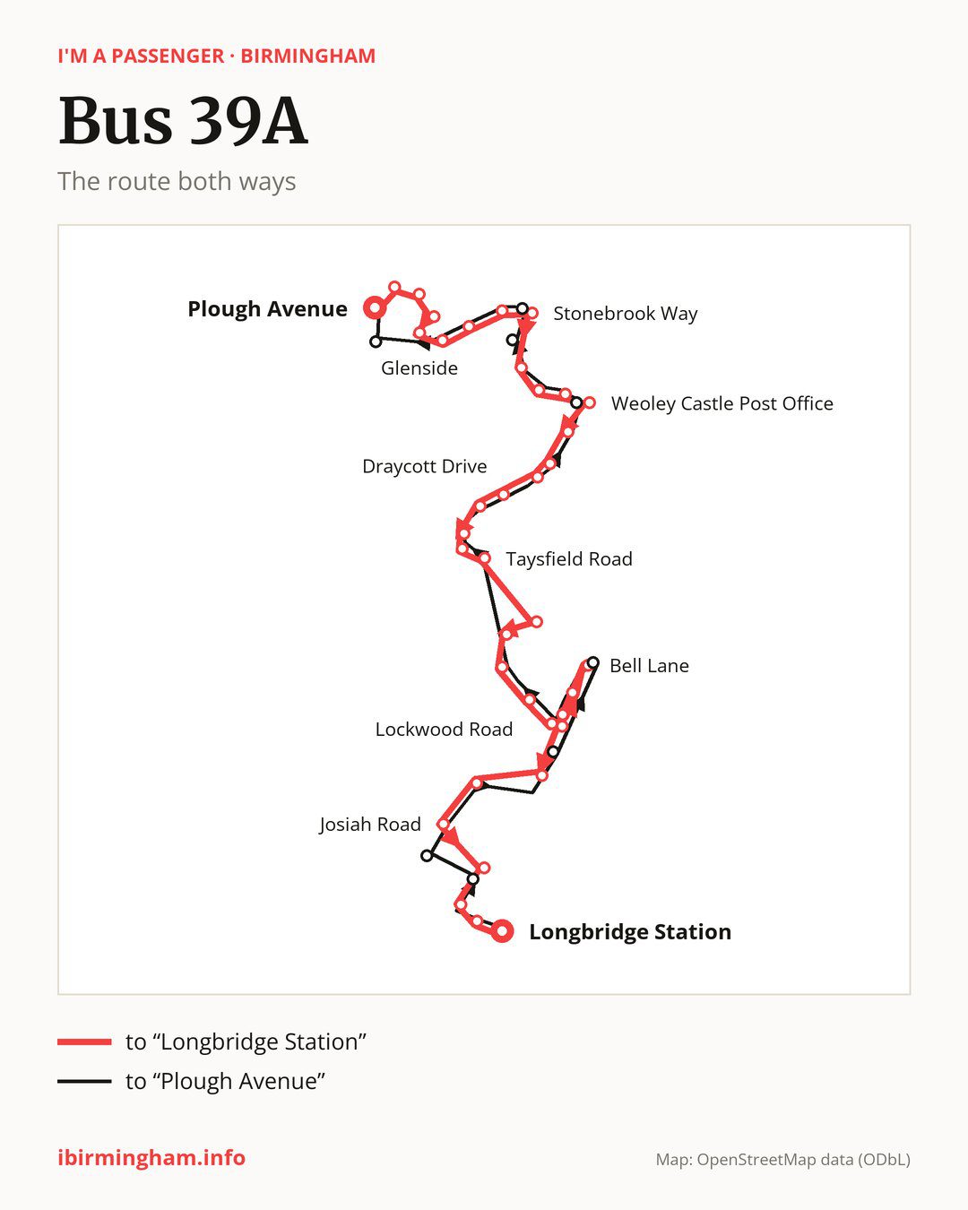
Towards “Longbridge Station”: 35 stops. After “Plough Avenue”, the bus calls at “Tibbatts Close”, “Warstone Avenue”, “Wood Leasow”, “Glenside”, “Stonehouse Grove”, “Simmons Leasow”, “Hillcrest School”, “Stonebrook Way”, “Overfield Drive”, “Shenley Lane”. Then “Ilmington Road”, “Weoley Castle Post Office”, “Bentley Grove”, “The Weoley Castle”, “Shenley Academy”, “Draycott Drive”, “Clavedon Close”, “Homedene Road”, “Bangham Pit Road”, “Taysfield Road”. Then “Vineyard Lane”, “School Playing Fields”, “Colworth Road”, “Lockwood Road”, “The Black Horse”, “Northfield Leisure Centre”, “Bell Lane”, “South Road”, “Hanging Lane”, “Josiah Road”. Before “Longbridge Station”: “Tessall Lane”, “Longbridge Technology Park”, “Devon Way”.
On the way back the bus takes a different route, from “Longbridge Station” to “Plough Avenue” (33 stops). Only in this direction does it call at “Farren Road”, “Lydiate Avenue”, “Quarry Lane”, “Northfield Shopping”, “Somerford Road”, “Middle Acre Road”, “Woodgate Valley Fire Station” and “Sommerfield Road”. Only in the direction of “Longbridge Station” does it call at, among others, “Tibbatts Close”, “Warstone Avenue”, “Wood Leasow”, “Glenside”, “Stonebrook Way” and “Weoley Castle Post Office”. For the way back, board nearby: “Tibbatts Close” → “Plough Avenue” (250 m), “Wood Leasow” → “Stonehouse Grove” (200 m), “Glenside” → “Stonehouse Grove” (200 m) and “Stonebrook Way” → “Woodgate Valley Fire Station” (100 m). Towards “Longbridge Station”, board nearby: “Farren Road” → “Tessall Lane” (150 m), “Lydiate Avenue” → “Josiah Road” (300 m), “Quarry Lane” → “South Road” (250 m) and “Northfield Shopping” → “Bell Lane” (50 m).
Left column runs down, right column runs up. Filled stops are served both ways, dashed ones only one way: 10 towards “Longbridge Station” and 8 the other way. Tap a stop to see its name.
Connections
On part of the route, between “Stonebrook Way” and “Longbridge Station” it shares the road with route 39; between “Plough Avenue” and “Hillcrest School” it shares the road with route 23; between “The Black Horse” and “Bell Lane” it shares the road with routes 55 and 61.
Connections by stop, in route order:
- “Wood Leasow” (only towards “Longbridge Station”): bus X22
- “Glenside” (only towards “Longbridge Station”): bus X22
- “Stonehouse Grove”: bus X22
- “Simmons Leasow”: bus X22
- “Hillcrest School”: buses 48 and X22
- “Stonebrook Way” (only towards “Longbridge Station”): buses 48 and X22
- “Overfield Drive”: bus 48
- “Ilmington Road”: buses 48 and X21
- “Weoley Castle Post Office” (only towards “Longbridge Station”): buses 48 and X21
- Stops from “Bentley Grove” to “Shenley Academy”: buses 48 and X21
- “Draycott Drive”: buses 18, 48 and X21
- “Clavedon Close”: buses 18 and X21
- Stops from “Homedene Road” to “Taysfield Road”: bus 18
- “School Playing Fields” (only towards “Longbridge Station”): bus 18
- “Colworth Road”: buses 18 and 27
- “Lockwood Road”: buses 18, 19, 27, 48, 63 and X20
- “The Black Horse”: buses 18, 19, 27, 48, 63 and X20
- “Northfield Leisure Centre” (only towards “Longbridge Station”): buses 18, 19, 27, 48, 63 and X20
- “Bell Lane”: buses 18, 19, 27, 48, 63 and X20
- “South Road”: buses 19, 63 and X20
- “Tessall Lane” (only towards “Longbridge Station”): buses 63 and X20
- “Longbridge Technology Park”: buses 19, 45, 47, 49, 63 and X20
- “Devon Way”: buses 19, 45, 47, 49, 63 and X20
- “Longbridge Station”: buses 19, 45, 47 and 49
- “Farren Road” (only towards “Plough Avenue”): buses 63 and X20
- “Quarry Lane” (only towards “Plough Avenue”): buses 18, 19, 27, 48, 63 and X20
- “Northfield Shopping” (only towards “Plough Avenue”): buses 18, 19, 27, 48, 63 and X20
- “Somerford Road” (only towards “Plough Avenue”): buses 48 and X21
- “Middle Acre Road” (only towards “Plough Avenue”): buses 48 and X22
- “Woodgate Valley Fire Station” (only towards “Plough Avenue”): buses 48 and X22
Pages for these routes: bus X20, bus X21, bus X22, bus 18, bus 19, bus 23, bus 27, bus 39, bus 45, bus 47, bus 48, bus 49, bus 55, bus 61, bus 63.
Passes and concessions
Which passes are available and who travels free is explained on a separate page: how to pay for public transport in Birmingham.
Questions about bus 39A
Does bus 39A go to “Longbridge Technology Park”?
Yes, in both directions.
Where can I change from bus 39A to another bus route?
Most routes stop at “Lockwood Road” and “The Black Horse” (18, 19, 27, 48, 63 and X20). All other stops with connections are listed above.
Checked on 25 September 2026. Source of the route and stops: National Express West Midlands.