
Bus route 937 in Birmingham links “Old Square” and “Rising Sun Island”. One stop is served in one direction only.
Where bus 937 goes
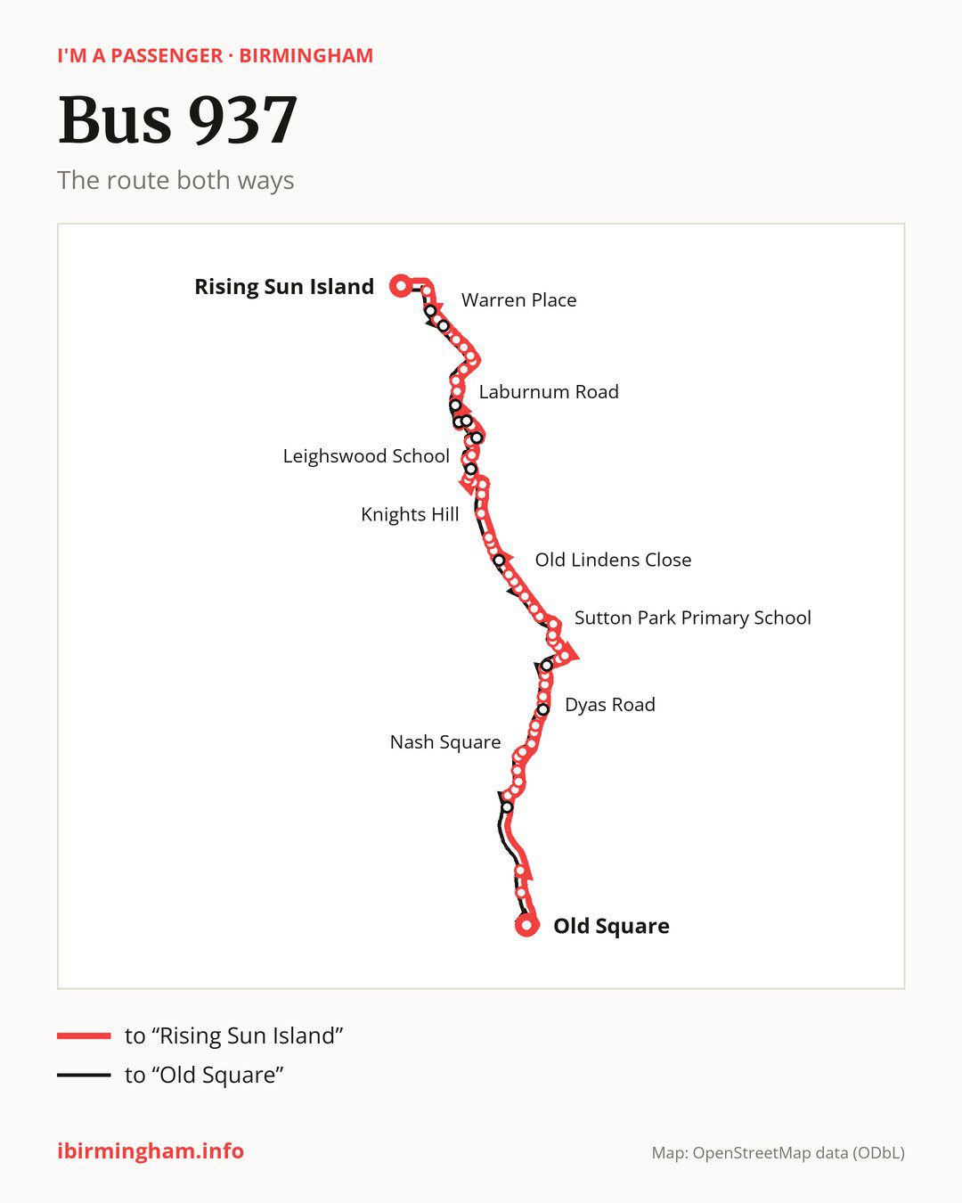
Towards “Rising Sun Island”: 63 stops. After “Old Square”, the bus calls at “Ryder Street”, “Lower Tower Street”, “Milton Street”, “Perry Barr Rail Station”, “Wellhead Lane”, “Holford Drive”, “Nash Square”, “Perry Park”, “Aldridge Road”, “Elmbridge Road”. Then “Crossway Lane”, “Greenholm Road”, “Melverley Grove”, “Dyas Road”, “Hotspur Road”, “Rushden Croft”, “Harringay Road”, “Kingstanding Library”, “Winterton Road”, “Longmoor Road”. Then “Sutton Park Primary School”, “Westwood Road”, “King George V Field”, “Sutton Oak Corner”, “The Queslett”, “Hundred Acre Road”, “Farmer Johns”, “Old Lindens Close”, “Barr Common Farm”, “Lowlands Avenue”. Then “Beacon Hill”, “Bronstone Stables”, “Little Hardwick Road”, “Valley Nurseries”, “Knights Hill”, “St Francis College”, “Hallcroft Way”, “Rookery Lane”, “The Avion”, “Aldridge Shopping Centre”. Then “Greenfields”, “Leighswood School”, “Wellfield Road”, “Lazy Hill Road”, “Glendower Road”, “Jessie Road”, “Herbert Road”, “Castle Road”, “Laburnum Road”, “Streets Corner”. Then “Shire Oak Hill”, “Shire Oak Close”, “Adams Road”, “Friezland Lane”, “Anchor Bridge”, “Warren Place”, “Brickiln Street”, “Raven’s Court”, “Holland Park”, “Watling St Primary School”. Before “Rising Sun Island”: “Hednesford Road”.
On the way back, from “Rising Sun Island” to “Old Square”: 66 stops. Only in this direction does it call at, among others, “The Park View Centre”, “Silver Street”, “Sunnyside”, “Longleat Road”, “Walton Road” and “Norfolk Crescent”. Only in the direction of “Rising Sun Island” does it call at, among others, “Ryder Street”, “Perry Barr Rail Station”, “Aldridge Road”, “Dyas Road”, “Kingstanding Library” and “Beacon Hill”. For the way back, board nearby: “Ryder Street” → “Dalton Street” (100 m), “Perry Barr Rail Station” → “Wellhead Lane” (300 m), “Aldridge Road” → “Perry Park” (200 m) and “Dyas Road” → “Westward Close” (200 m). Towards “Rising Sun Island”, board nearby: “The Park View Centre” → “Holland Park” (50 m), “Silver Street” → “Warren Place” (100 m), “Sunnyside” → “Castle Road” (50 m) and “Longleat Road” → “Herbert Road” (100 m).
Left column runs down, right column runs up. Filled stops are served both ways, dashed ones only one way: 9 towards “Rising Sun Island” and 12 the other way. Tap a stop to see its name.
Other routes along the way
On part of the route, between “Old Square” and “Kingstanding Library” it shares the road with route 936; between “Perry Barr Rail Station” and “Melverley Grove” it shares the road with route 33; between “Ryder Street” and “Aldridge Road” it shares the road with route 907.
Connections by stop, in route order:
- “Old Square”: buses 2, 4A, 5, 6, 7, 14, 16, 16A, 23, 24, 45, 47, 51, 61, 63, 65, 66, 67, 68, 74, 82, 87, 94, 95, 97, 97A, FD, X1, X2, X4, X5, X12, X14, X15, X20, X21, X22, X51 and X64
- “Ryder Street” (only towards “Rising Sun Island”): buses 14, 16, 16A, 51, 61, 63, 65, 66, 67, 68, 74, 82, 87, 94, 95, FD, X1, X2, X4, X5, X12, X14, X15, X20, X21, X22, X51 and X64
- “Lower Tower Street”: buses 7, 51, 65, 67, 68 and X64
- “Milton Street”: buses 7 and 51
- “Perry Barr Rail Station” (only towards “Rising Sun Island”): buses 11A, 51, 52 and 54A
- “Wellhead Lane”: buses 11A, 51, 52 and 54A
- “Holford Drive”: buses 51 and 52
- “Nash Square”: buses 51 and 52
- “Melverley Grove”: bus 28
- “Dyas Road” (only towards “Rising Sun Island”): bus 28
- “Hotspur Road”: buses 28 and 96
- “Rushden Croft”: bus 96
- “Harringay Road”: bus 96
- “Kingstanding Library” (only towards “Rising Sun Island”): buses 77, 77A and 96
- “Winterton Road”: buses 77, 77A and 96
- Stops from “Longmoor Road” to “Hundred Acre Road”: buses 77 and 77A
- “Beacon Hill” (only towards “Rising Sun Island”): buses 77 and 77A
- “Bronstone Stables”: buses 77 and 77A
- “The Foley Arms” (only towards “Old Square”): buses 77 and 77A
- “Westward Close” (only towards “Old Square”): bus 28
- “Bragg Road” (only towards “Old Square”): buses 11A, 51, 52 and 54A
- “Dalton Street” (only towards “Old Square”): buses 2, 4A, 5, 6, 7, 14, 16, 16A, 23, 24, 45, 47, 51, 61, 63, 65, 66, 67, 68, 74, 82, 87, 94, 95, 97, 97A, FD, X1, X2, X4, X5, X12, X14, X15, X20, X21, X22, X51 and X64
Pages for these routes: bus FD, bus X12, bus X14, bus X15, bus X2, bus X20, bus X21, bus X22, bus X4, bus X5, bus X64, bus 2, bus 4A, bus 5, bus 6, bus 7, bus 14, bus 16, bus 16A, bus 23, bus 24, bus 28, bus 33, bus 45, bus 47, bus 51, bus 52, bus 54A, bus 61, bus 63, bus 65, bus 66, bus 67, bus 68, bus 74, bus 77, bus 77A, bus 82, bus 87, bus 94, bus 95, bus 96, bus 97, bus 97A, bus 907, bus 936.
Passes and concessions
Tickets, passes and concessions are covered on a separate page: how to pay for public transport in Birmingham.
Questions and answers
Does bus 937 go to “Perry Park”?
Yes, in both directions.
Where can I change from bus 937 to another bus route?
Most routes stop at “Old Square” (2, 4A, 5, 6, 7, 14, 16, 16A, 23, 24, 45, 47, 51, 61, 63, 65, 66, 67, 68, 74, 82, 87, 94, 95, 97, 97A, FD, X1, X2, X4, X5, X12, X14, X15, X20, X21, X22, X51 and X64) and “Dalton Street” (only towards “Old Square”; 2, 4A, 5, 6, 7, 14, 16, 16A, 23, 24, 45, 47, 51, 61, 63, 65, 66, 67, 68, 74, 82, 87, 94, 95, 97, 97A, FD, X1, X2, X4, X5, X12, X14, X15, X20, X21, X22, X51 and X64). All other stops with connections are listed above.
Checked on 3 October 2026. Source of the route and stops: National Express West Midlands.