
Bus route 19 in Birmingham goes from “Manningford Road” to “Supermarket”. One stop is served in one direction only. The return journey ends at “Maypole Shops” (200 m from “Manningford Road”).
Which way bus 19 runs
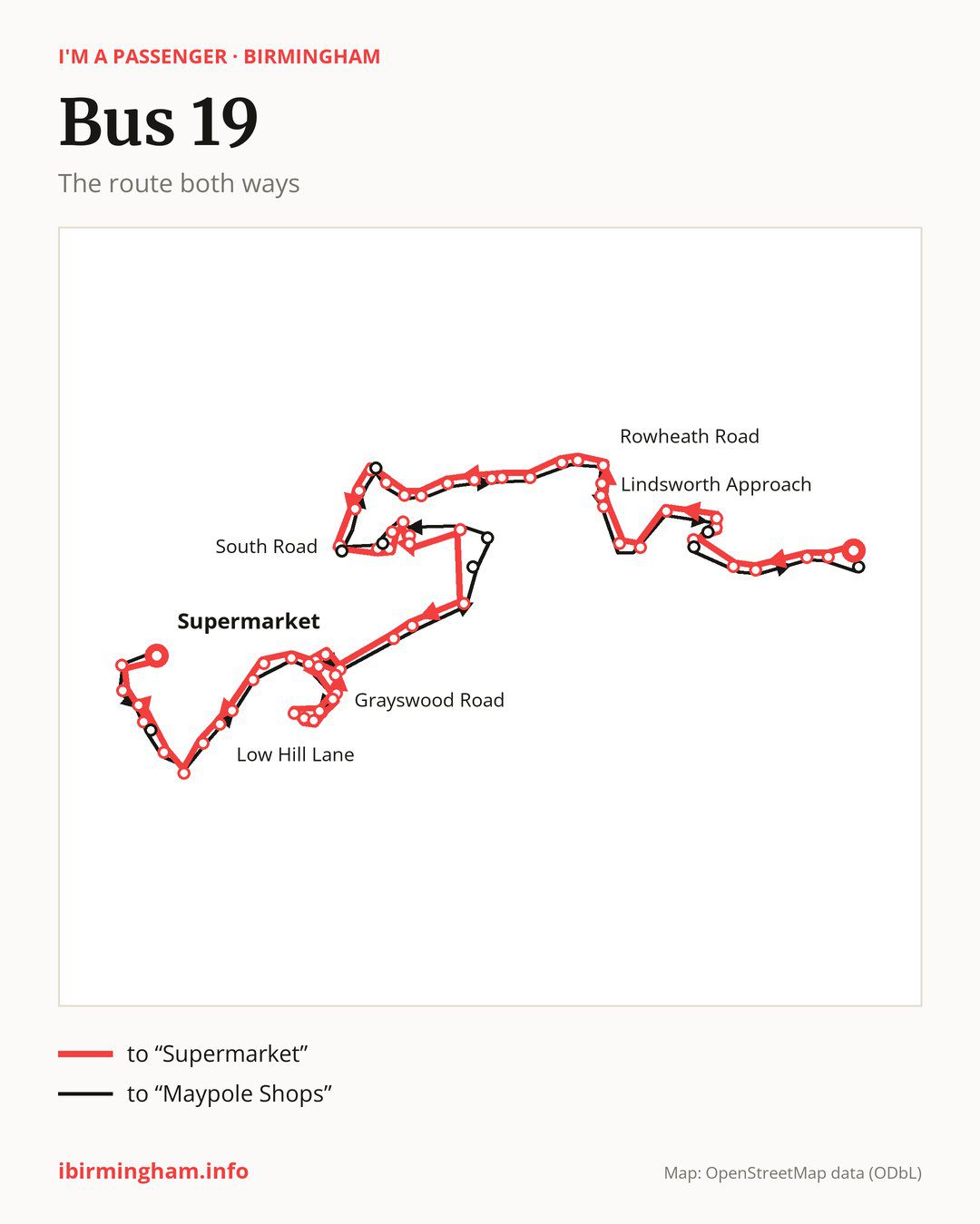
Towards “Supermarket”: 60 stops. After “Manningford Road”, the bus calls at “Baverstock Road”, “Pennyacre Road”, “Brockworth Road”, “Bells Farm Close”, “Broadmeadow Close”, “Beechwood Court”, “Lindsworth Approach”, “Elderfield Road”, “Shortlands Close”, “The Green”. Then “Melchett Road”, “Camp Lane”, “Kings Norton Station”, “Rowheath Road”, “Station Road”, “Selly Oak Road”, “Longfellow Road”, “Stepwood Croft”, “Middleton Hall Road”, “Lindsey Avenue”. Then “Overbury Road”, “Innage Road”, “Beech House”, “Telephone Exchange”, “Bell Lane”, “Lockwood Road”, “Northfield Leisure Centre”, “South Road”, “Quarry Lane”, “Northfield Station Car Park”. Then “Church Hill”, “Woodland Road”, “Northfield Rail Station”, “Middlemore Road”, “Slingfield Road”, “Edgehill Road”, “Flats”, “Turves Green”, “Culmington Grove”, “Coney Green House”. Then “Longbridge Station”, “Grayswood Road”, “The Thurlestone”, “Lannacombe Road”, “Ilsham Grove”, “Edenhurst Road”, “Burnside Way”, “Devon Way”, “South and City College”, “Longbridge Island”. Before “Supermarket”: “Tinmeadow Crescent”, “Low Hill Lane”, “Edgewood Road”, “Leach Green Lane”, “Meadvale Road”, “Cliff Rock Road”, “Ridgewater Close”, “Leach Heath Lane”.
On the way back, from “Supermarket” to “Maypole Shops”: 58 stops. After “Leach Green Lane”, the bus runs a loop via “Leach Heath Lane”, “Cliff Rock Road”, “Chadwick Avenue” and “Meadvale Road” and returns to “Leach Green Lane”. Only in this direction does it call at, among others, “Chadwick Avenue”, “Oddingley Road”, “Popes Lane”, “Copse Close”, “Fire Station” and “Bristol Road”. Only in the direction of “Supermarket” does it call at, among others, “Broadmeadow Close”, “Beechwood Court”, “Camp Lane”, “Selly Oak Road”, “Bell Lane” and “South Road”. For the way back, board nearby: “Broadmeadow Close” → “Broadmeadow School” (100 m), “Beechwood Court” → “Keynell Covert” (100 m), “Camp Lane” → “Melchett Road” (150 m) and “Selly Oak Road” → “Station Road” (200 m). Towards “Supermarket”, board nearby: “Chadwick Avenue” → “Ridgewater Close” (100 m), “Popes Lane” → “Middlemore Road” (350 m), “Copse Close” → “Northfield Station Car Park” (100 m) and “Fire Station” → “South Road” (50 m).
Left column runs down, right column runs up. Filled stops are served both ways, dashed ones only one way: 11 towards “Supermarket” and 9 the other way. Tap a stop to see its name.
Connections
On part of the route, between “Middleton Hall Road” and “Lockwood Road” it shares the road with routes 18 and 27; between “Longbridge Station” and “Leach Green Lane” it shares the road with route 47; between “Grayswood Road” and “Longbridge Island” it shares the road with route 45.
Connections by stop, in route order:
- “Manningford Road”: buses 2 and 50
- “Baverstock Road”: buses 2 and 50
- “Brockworth Road”: bus 50
- “Bells Farm Close”: buses 35 and 50
- “Broadmeadow Close” (only towards “Supermarket”): bus 35
- “Beechwood Court” (only towards “Supermarket”): bus 35
- “Lindsworth Approach”: bus 35
- “Camp Lane” (only towards “Supermarket”): bus 55
- Stops from “Kings Norton Station” to “Station Road”: buses 11A and 55
- “Selly Oak Road” (only towards “Supermarket”): bus 55
- “Stepwood Croft”: bus 55
- “Middleton Hall Road”: bus 55
- Stops from “Overbury Road” to “Beech House”: bus 48
- “Telephone Exchange”: buses 39, 39A, 48, 55, 61 and 63
- “Bell Lane” (only towards “Supermarket”): buses 39, 39A, 48, 55, 61 and 63
- “Lockwood Road”: buses 39, 39A, 48, 55, 61 and 63
- “Northfield Leisure Centre”: buses 39, 39A, 48, 55, 61 and 63
- “South Road” (only towards “Supermarket”): buses 39, 39A and 63
- “Quarry Lane”: buses 39, 39A and 63
- Stops from “Northfield Station Car Park” to “Woodland Road”: bus 48
- “Northfield Rail Station” (only towards “Supermarket”): bus 48
- “Edgehill Road”: bus 48
- “Flats”: bus 48
- “Turves Green”: buses 39, 39A and 55
- “Culmington Grove”: buses 39, 39A and 55
- “Coney Green House” (only towards “Supermarket”): buses 39, 39A and 55
- “Longbridge Station”: buses 39, 39A and 55
- “Burnside Way”: buses 39, 39A and 55
- “Devon Way”: buses 39, 39A, 55 and 63
- “South and City College” (only towards “Supermarket”): buses 39, 39A, 55 and 63
- “Longbridge Island”: buses 55 and 63
- Stops from “Tinmeadow Crescent” to “Edgewood Road”: bus 55
- “Meadvale Road”: bus 55
- “Cliff Rock Road”: bus 55
- “Ridgewater Close” (only towards “Supermarket”): bus 55
- “Leach Heath Lane”: buses 55 and 63
- “Supermarket”: buses 55 and 63
- “Chadwick Avenue” (only towards “Maypole Shops”): bus 55
- “Copse Close” (only towards “Maypole Shops”): bus 48
- “Fire Station” (only towards “Maypole Shops”): buses 39, 39A and 63
- “Bristol Road” (only towards “Maypole Shops”): buses 39, 39A, 48, 55, 61 and 63
- “Keynell Covert” (only towards “Maypole Shops”): bus 35
- “Broadmeadow School” (only towards “Maypole Shops”): bus 35
- “Maypole Shops”: buses 2, 50 and 665
Pages for these routes: bus 2, bus 18, bus 27, bus 35, bus 39, bus 39A, bus 45, bus 47, bus 48, bus 50, bus 55, bus 61, bus 63.
Passes and concessions
Which passes are available and who travels free is explained on a separate page: how to pay for public transport in Birmingham.
Questions about bus 19
Does bus 19 go to “Kings Norton Station”?
Yes, in both directions.
Where can I change from bus 19 to another bus route?
Most routes stop at “Telephone Exchange” (39, 39A, 48, 55, 61 and 63) and “Bell Lane” (only towards “Supermarket”; 39, 39A, 48, 55, 61 and 63). All other stops with connections are listed above.
Checked on 2 October 2026. Source of the route and stops: National Express West Midlands.