
Bus route X4 in Birmingham goes from “The Square Peg” to “Churchill Parade”.
The route of bus X4
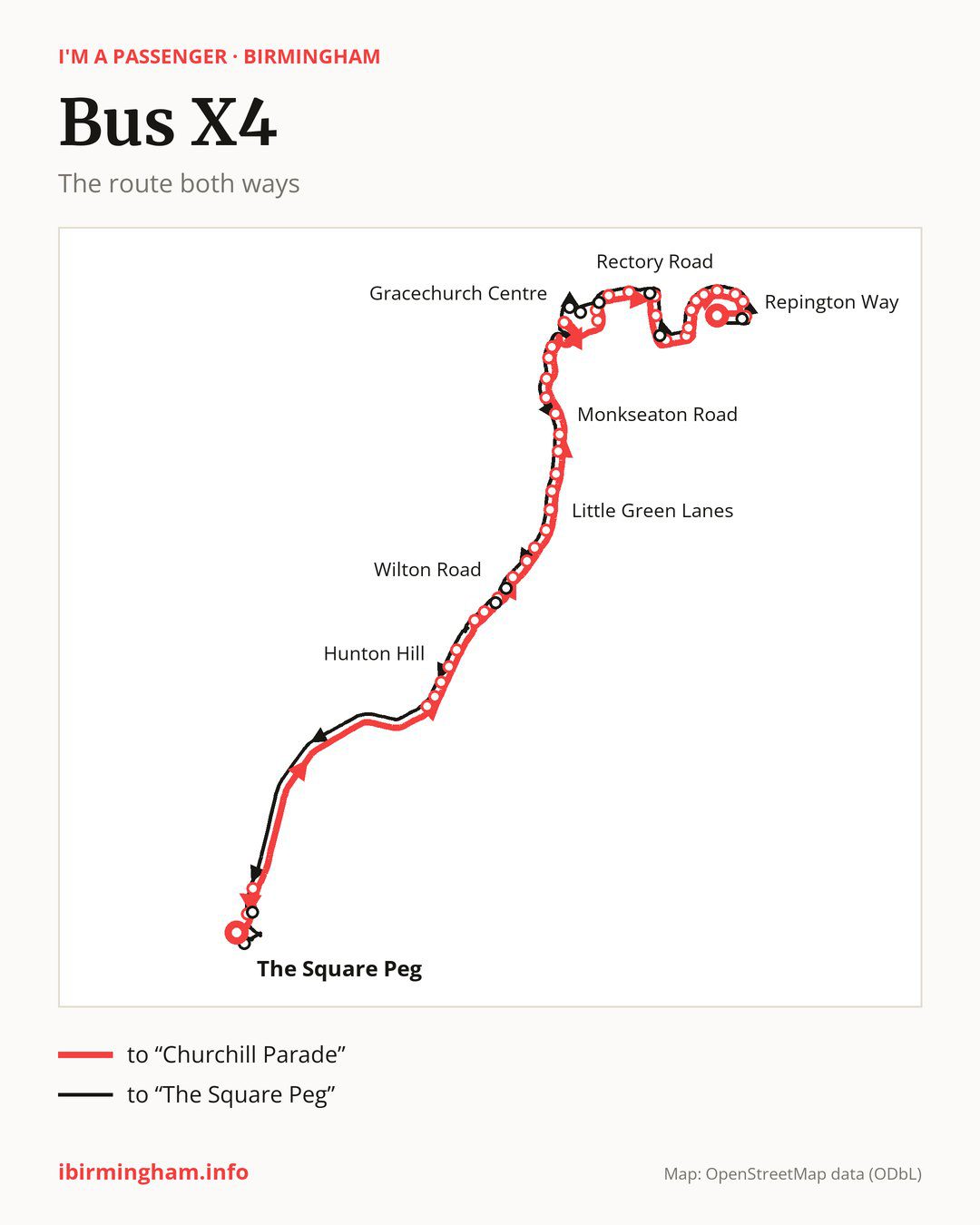
Towards “Churchill Parade”: 43 stops. After “The Square Peg”, the bus calls at “Law Courts”, “Aston University”, “The Mount”, “Hillaries Road”, “Hunton Hill”, “St Mary & St John Church”, “Fentham Road”, “Six Ways Island”, “Barnabas Road”, “Wilton Road”. Then “Orchard Road”, “Fairbourne Tower”, “Kentmere Tower”, “Harman Road”, “Little Green Lanes”, “Greenhill Road”, “Oakhurst Road”, “Green Lanes”, “Vesey Road”, “Monkseaton Road”. Then “Horse and Jockey”, “Maney Hill Road”, “Duke Street”, “Manor Hill”, “Gracechurch Centre”, “Coleshill Road”, “Riland Grove”, “Good Hope Hospital”, “Rehabilitation Centre”, “Rectory Road”. Then “St Chads Church”, “Stanley Avenue”, “John Willmott School”, “Fairfax School”, “Glover Road”, “Horsfall Road”, “Chadwick Road”, “Carhampton Road”, “Leigh Road”, “Repington Way”. Before “Churchill Parade”: “Wyatt Road”.
On the way back, from “Churchill Parade” to “The Square Peg”: 45 stops. Only in this direction does it call at, among others, “Holbeche Road”, “Owen Court”, “West View Road”, “Riland Road”, “Midland Drive” and “Trinity Church”. Only in the direction of “Churchill Parade” does it call at, among others, “Law Courts”, “Hillaries Road”, “Wilton Road”, “Coleshill Road”, “Riland Grove” and “Rectory Road”. For the way back, board nearby: “Law Courts” → “Ryder Street” (100 m), “Hillaries Road” → “The Mount” (200 m), “Wilton Road” → “New Street” (50 m) and “Coleshill Road” → “Riland Road” (250 m). Towards “Churchill Parade”, board nearby: “Holbeche Road” → “Wyatt Road” (50 m), “Owen Court” → “Stanley Avenue” (100 m), “West View Road” → “Rectory Road” (100 m) and “Riland Road” → “Riland Grove” (100 m).
Left column runs down, right column runs up. Filled stops are served both ways, dashed ones only one way: 9 towards “Churchill Parade” and 11 the other way. Tap a stop to see its name.
Other routes along the way
On part of the route, between “The Square Peg” and “Gracechurch Centre” it shares the road with route X5; between “Law Courts” and “Harman Road” it shares the road with route X15; between “The Mount” and “Wilton Road” it shares the road with route 66.
Connections by stop, in route order:
- “The Square Peg”: buses 2, 4A, 5, 6, 7, 12, 13, 14, 16, 16A, 23, 24, 33, 45, 47, 51, 52, 61, 63, 65, 67, 68, 74, 82, 87, 94, 95, 97, 97A, 101, 907, 936, 937, 997, 998, FD, X1, X2, X12, X14, X20, X21, X22, X51 and X64
- “Law Courts” (only towards “Churchill Parade”): buses 14, 16, 16A, 33, 51, 65, 67, 68, 74, 82, 87, 94, 95, 907, 936, 937, 997, 998, FD, X12, X14, X20, X21, X22, X51 and X64
- “Aston University”: buses 65, 67, 68, X14 and X64
- “The Mount”: buses X14 and X64
- “Hillaries Road” (only towards “Churchill Parade”): buses X14 and X64
- “Hunton Hill”: buses X14 and X64
- “St Mary & St John Church”: buses X14 and X64
- “Fentham Road”: bus X64
- “Six Ways Island”: buses 11A, 77, 77A, 96 and X64
- “Barnabas Road”: buses 11A, 77, 77A, 96 and X64
- “Wilton Road” (only towards “Churchill Parade”): buses 77, 77A and 96
- “Orchard Road”: buses 77, 77A and 96
- Stops from “Monkseaton Road” to “Maney Hill Road”: buses 77 and 907
- “Duke Street”: buses 77, 77A and 907
- “Manor Hill”: buses 77, 77A, 907 and X14
- “Gracechurch Centre”: buses 71A, 77, 77A, 907 and X14
- “Coleshill Road” (only towards “Churchill Parade”): buses 77, 77A and X14
- “Riland Grove” (only towards “Churchill Parade”): buses 77, 77A and X14
- “Good Hope Hospital”: bus X14
- “Rehabilitation Centre”: bus X14
- “Rectory Road” (only towards “Churchill Parade”): bus X14
- “St Chads Church”: bus X14
- “Glover Road”: bus X14
- “Horsfall Road”: bus X14
- “Chadwick Road” (only towards “Churchill Parade”): bus X14
- “Carhampton Road”: bus X14
- “Repington Way”: bus X14
- “Wyatt Road” (only towards “Churchill Parade”): bus X14
- “Churchill Parade”: bus X14
- “Churchill Road”: bus X14
- “Holbeche Road” (only towards “The Square Peg”): bus X14
- “West View Road” (only towards “The Square Peg”): bus X14
- “Riland Road” (only towards “The Square Peg”): bus X14
- “Midland Drive” (only towards “The Square Peg”): buses 71A, 77, 77A, 907 and X14
- “Trinity Church” (only towards “The Square Peg”): buses 71A, 77, 77A, 907 and X14
- “Edwards Road” (only towards “The Square Peg”): buses 77, 77A and 96
- “New Street” (only towards “The Square Peg”): buses 77, 77A and 96
- “Ryder Street” (only towards “The Square Peg”): buses 14, 16, 16A, 33, 51, 65, 67, 68, 74, 82, 87, 94, 95, 907, 936, 937, 997, 998, FD, X12, X14, X51 and X64
- “Dale House” (only towards “The Square Peg”): buses 2, 4A, 5, 6, 14, 16, 16A, 17, 17A, 23, 24, 33, 35, 45, 47, 50, 51, 60, 61, 63, 65, 67, 68, 74, 82, 87, 94, 95, 97, 97A, 907, 936, 937, 997, 998, FD, X1, X2, X12, X14, X20, X21, X22, X51 and X64
Pages for these routes: bus FD, bus X12, bus X14, bus X15, bus X2, bus X20, bus X21, bus X22, bus X5, bus X64, bus 2, bus 4A, bus 5, bus 6, bus 7, bus 12, bus 13, bus 14, bus 16, bus 16A, bus 17, bus 17A, bus 23, bus 24, bus 33, bus 35, bus 45, bus 47, bus 50, bus 51, bus 52, bus 60, bus 61, bus 63, bus 65, bus 66, bus 67, bus 68, bus 71A, bus 74, bus 77, bus 77A, bus 82, bus 87, bus 94, bus 95, bus 96, bus 97, bus 97A, bus 101, bus 907, bus 936, bus 937, bus 997, bus 998.
Passes and concessions
Tickets, passes and concessions are covered on a separate page: how to pay for public transport in Birmingham.
Questions about bus X4
Does bus X4 go to “Aston University”?
Yes, in both directions.
Where can I change from bus X4 to another bus route?
Most routes stop at “The Square Peg” (2, 4A, 5, 6, 7, 12, 13, 14, 16, 16A, 23, 24, 33, 45, 47, 51, 52, 61, 63, 65, 67, 68, 74, 82, 87, 94, 95, 97, 97A, 101, 907, 936, 937, 997, 998, FD, X1, X2, X12, X14, X20, X21, X22, X51 and X64) and “Dale House” (only towards “The Square Peg”; 2, 4A, 5, 6, 14, 16, 16A, 17, 17A, 23, 24, 33, 35, 45, 47, 50, 51, 60, 61, 63, 65, 67, 68, 74, 82, 87, 94, 95, 97, 97A, 907, 936, 937, 997, 998, FD, X1, X2, X12, X14, X20, X21, X22, X51 and X64). All other stops with connections are listed above.
Checked on 28 September 2026. Source of the route and stops: National Express West Midlands.