
Bus route 12 in Birmingham links “Colmore Row” and “Coronation Gardens”. One stop is served in one direction only.
The route of bus 12
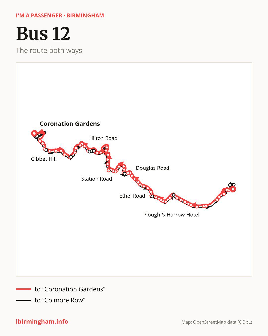
From “Colmore Row” to “Coronation Gardens”: 64 stops. On the way: “Art Gallery”, “Newhall Street”, “Library Metro”, “Brindleyplace Metro”, “Five Ways Metro”, “Edgbaston Village Metro”, “Plough & Harrow Hotel”, “Monument Road”, “Strathallen Hotel”, “York Road”. Then “Vernon Road”, “Deblen Drive”, “Stanmore Road”, “George Dixon Academy”, “Bernard Road”, “Beverley House”, “Barnsley Road”, “Drayton Road”, “Willow Avenue”, “The Bear Tavern”. Then “Ethel Road”, “Gladys Road”, “Addenbrooke Road”, “Thimblemill Cemetery”, “William Road”, “Hales Lane”, “Queens Road”, “Douglas Road”, “Basons Lane”, “Darby Road”. Then “Crosswells Road”, “Richmond Hill”, “Tat Bank Crossroads”, “Langley Green Station”, “Station Road”, “Mill Lane”, “Underhill Street”, “Titford Road”, “Park Street”, “Park Lane Industrial Estate”. Then “Oldbury Ringway”, “Oldbury Interchange”, “Sandwell Council House”, “Wharfside”, “Chapel Street”, “Brades Road”, “Bath Row”, “Bury Hill Road”, “Hilton Road”, “Lower City Road”. Then “Poplar Avenue”, “Poplar Rise”, “Hawfield Road”, “St Andrews Drive”, “Warrens Hall Farm”, “Gibbet Hill”, “Tansley Hill Avenue”, “View Drive”, “Blackacre Road”, “St John’s Road”. Before “Coronation Gardens”: “North Street”, “Wolverhampton Street”.
The return journey is different. Towards “Colmore Row”: 61 stops. Only in this direction does it call at, among others, “St Edmunds Church”, “Bennetts Hill”, “Portway Hill”, “Wolverhampton Road”, “no. 54” and “Rounds Green School”. Only in the direction of “Coronation Gardens” does it call at, among others, “Art Gallery”, “Deblen Drive”, “George Dixon Academy”, “Willow Avenue”, “Ethel Road” and “Crosswells Road”. For the way back, board nearby: “Art Gallery” → “Newhall Street” (150 m), “Deblen Drive” → “Stanmore Road” (250 m), “George Dixon Academy” → “St Germain’s Church” (100 m) and “Willow Avenue” → “Drayton Road” (150 m). Towards “Coronation Gardens”, board nearby: “St Edmunds Church” → “Coronation Gardens” (250 m), “Bennetts Hill” → “Blackacre Road” (150 m), “Portway Hill” → “St Andrews Drive” (100 m) and “Wolverhampton Road” → “Bath Row” (100 m).
Left column runs down, right column runs up. Filled stops are served both ways, dashed ones only one way: 14 towards “Coronation Gardens” and 11 the other way. Tap a stop to see its name.
Where to change
Shared sections with other routes: between “Colmore Row” and “The Bear Tavern” it shares the road with route 13; between “Colmore Row” and “Five Ways Metro” it shares the road with routes 23 and 24; between “George Dixon Academy” and “Drayton Road” it shares the road with routes 11A and 22.
Connections by stop, in route order:
- “Colmore Row”: buses 7, 16, 16A, 52, 74, 82, 87, 101, X4, X5, X14, X15, X20, X21 and X22
- “Art Gallery” (only towards “Coronation Gardens”): buses 52, 82, 87 and 101
- “Newhall Street”: buses 82, 87 and 101
- “Library Metro”: buses 82 and 87
- “Edgbaston Village Metro”: buses 1 and 80
- “Plough & Harrow Hotel”: bus 1
- “Stanmore Road”: bus 80
- “George Dixon Academy” (only towards “Coronation Gardens”): bus 80
- “Bernard Road”: bus 80
- “Barnsley Road”: buses 20, 21, 48 and 82
- “Drayton Road”: buses 20, 21, 48 and 82
- “Willow Avenue” (only towards “Coronation Gardens”): buses 20, 21, 48 and 82
- “The Bear Tavern”: buses 20, 21, 48 and 82
- “Ethel Road” (only towards “Coronation Gardens”): buses 20, 48 and 82
- “Gladys Road”: buses 54 and 82
- “Addenbrooke Road”: bus 54
- “Thimblemill Cemetery”: bus 54
- “William Road”: buses 48, 54 and 89
- “Hales Lane”: buses 48, 54 and 89
- “Queens Road”: buses 21, 48 and 89
- “Douglas Road”: buses 21, 48 and 89
- “Basons Lane”: buses 21 and 48
- “Darby Road”: bus 21
- “Richmond Hill”: bus 21
- “Tat Bank Crossroads”: bus 21
- “Park Street”: buses 4, 4H and 4M
- “Park Lane Industrial Estate”: buses 4, 4H, 4M and 87
- Stops from “Oldbury Ringway” to “Sandwell Council House”: buses 3, 3A, 4, 4H, 4M, 21 and 87
- “Wharfside”: buses 3, 3A and 87
- “Chapel Street”: buses 3 and 3A
- “Coronation Gardens”: buses 74 and 87
- “St Edmunds Church” (only towards “Colmore Row”): buses 74 and 87
- “Thornwood Close” (only towards “Colmore Row”): bus 21
- “Wigorn Road” (only towards “Colmore Row”): buses 20, 21, 48 and 82
- “St Germain’s Church” (only towards “Colmore Row”): bus 80
- “Railway Bridge” (only towards “Colmore Row”): buses 7, 16, 16A, 52, 74, 82, 87 and 101
- “Lloyd House” (only towards “Colmore Row”): buses 7, 16, 16A, 52, 74, 82, 87, 101, X4, X5, X14 and X15
Pages for these routes: bus X14, bus X15, bus X20, bus X21, bus X22, bus X4, bus X5, bus 1, bus 3, bus 3A, bus 4, bus 4H, bus 4M, bus 7, bus 13, bus 16, bus 16A, bus 20, bus 21, bus 23, bus 24, bus 48, bus 52, bus 54, bus 74, bus 80, bus 82, bus 87, bus 89, bus 101.
Passes and concessions
Which passes are available and who travels free is explained on a separate page: how to pay for public transport in Birmingham.
Questions and answers
Does bus 12 go to “Library Metro”?
Yes, in both directions.
Where can I change from bus 12 to another bus route?
Most routes stop at “Colmore Row” (7, 16, 16A, 52, 74, 82, 87, 101, X4, X5, X14, X15, X20, X21 and X22) and “Lloyd House” (only towards “Colmore Row”; 7, 16, 16A, 52, 74, 82, 87, 101, X4, X5, X14 and X15). All other stops with connections are listed above.
Checked on 3 October 2026. Source of the route and stops: National Express West Midlands.