
Bus route 77A in Birmingham runs between “Walsall Bus Station” and “Six Ways Island”. One stop is served in one direction only.
The route of bus 77A
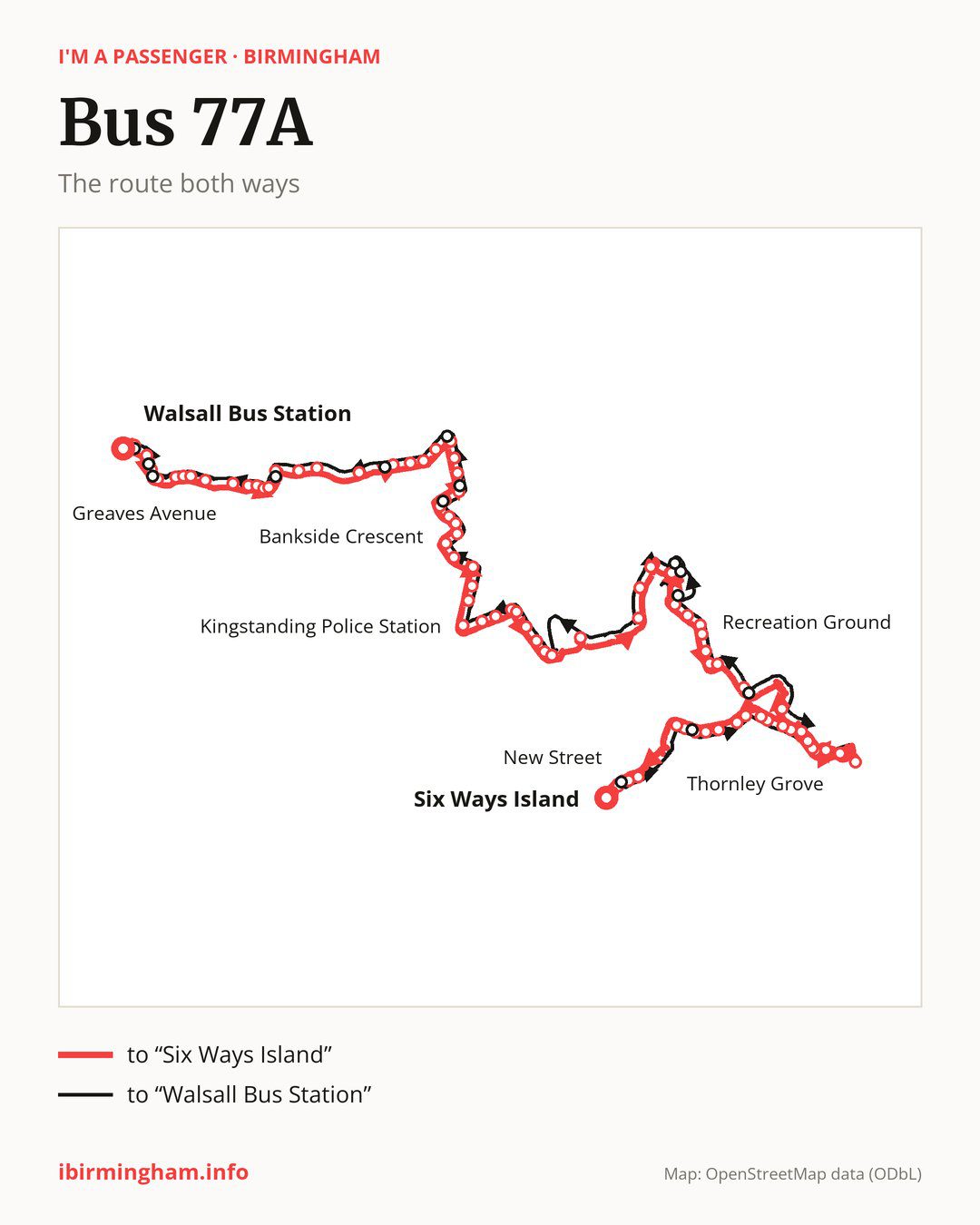
From “Walsall Bus Station” to “Six Ways Island”: 80 stops. On the way: “Walsall Town Hall”, “Upper Rushall Street”, “Pool Street”, “Bernard Street”, “Lumley Road”, “Beaconsfield Court”, “Orwell Road”, “Broadway North”, “Greaves Avenue”, “Appledore Road”. Then “Furze Way”, “Daffodil Road”, “Elmstead Close”, “Skip Lane”, “Walsall Garden Centre”, “Barr Beacon Crossroads”, “Aldridge Road”, “Hazelwood Road”, “Schoolacre Rise”, “Inglewood Grove”. Then “Grange Drive”, “Foley Court”, “The Milestone”, “Beacon Court”, “Bridlewood”, “Bankside Crescent”, “Hillside Drive”, “Moss Way”, “Brabham Crescent”, “Lindens Primary School”. Then “The Queslett”, “Sutton Oak Corner”, “King George V Field”, “Beacon Road”, “Kingstanding Police Station”, “Winterton Road”, “Hollyhurst Road”, “Chester Road”, “Monmouth Drive”, “Greenway Drive”. Then “Parkwood Drive”, “Tesco”, “The Beggars Bush”, “Halton Road Hail+Ride”, “Ashdene Close”, “Wyndley Lane”, “Fawdry Close”, “Gracechurch Centre”, “Shirley Drive”, “Douglas Road”. Then “Rowan Road”, “Shooters Hill”, “Recreation Ground”, “The Green”, “Bishop Walsh School”, “Allendale Road”, “Calder Drive Hail+Ride”, “Webster Way Hail+Ride”, “Walmley Ash Lane”, “Forge Croft”. Then “Asda Superstore”, “Thornley Grove”, “Arbury Walk”, “Walmley Junior School”, “Walmley Infant School”, “Ashurst Road”, “Ashfern Drive”, “Trident Close”, “Penns Lake Road”, “Penns Hall Hotel”. Before “Six Ways Island”: “The Chase”, “Berwood Road”, “Salisbury Grove”, “Beech Hill Road”, “Hart Road”, “Erdington Fire Station”, “New Street”, “Barnabas Road”.
The return journey is different. Towards “Walsall Bus Station”: 81 stops. After “Asda Superstore”, the bus runs a loop via “Thornley Grove” and “Arbury Walk” and returns to “Asda Superstore”. Only in this direction does it call at, among others, “Wilton Road”, “Fourlands Avenue”, “Walmley Road”, “Lower Queen Street”, “Trinity Hill” and “Trinity Church”. Only in the direction of “Six Ways Island” does it call at, among others, “Walsall Town Hall”, “Upper Rushall Street”, “Pool Street”, “Orwell Road”, “Aldridge Road” and “Grange Drive”. For the way back, board nearby: “Walsall Town Hall” → “Walsall Bus Station” (250 m), “Upper Rushall Street” → “Hill Street” (150 m), “Pool Street” → “Hill Street” (100 m) and “Orwell Road” → “Beaconsfield Court” (150 m). Towards “Six Ways Island”, board nearby: “Wilton Road” → “New Street” (100 m), “Fourlands Avenue” → “Berwood Road” (50 m), “Walmley Road” → “Allendale Road” (150 m) and “Lower Queen Street” → “Shirley Drive” (200 m).
Left column runs down, right column runs up. Filled stops are served both ways, dashed ones only one way: 14 towards “Six Ways Island” and 15 the other way. Tap a stop to see its name.
Where to change
Shared sections with other routes: between “Walsall Bus Station” and “The Beggars Bush” it shares the road with route 77; between “Grange Drive” and “The Queslett” it shares the road with route 998; between “Walmley Junior School” and “Beech Hill Road” it shares the road with route X15.
Connections by stop, in route order:
- “Walsall Bus Station”: buses 4, 4H, 4M, 22, 34, 37, 51, 637, 674, 997 and X51
- “Walsall Town Hall” (only towards “Six Ways Island”): buses 22, 51, 637, 674, 997 and X51
- “Upper Rushall Street” (only towards “Six Ways Island”): buses 51, 637, 674, 997 and X51
- “Pool Street” (only towards “Six Ways Island”): buses 51, 637 and X51
- “Bernard Street”: buses 51, 637 and X51
- “Lumley Road”: buses 51, 674 and X51
- “Beaconsfield Court”: bus 674
- “Orwell Road” (only towards “Six Ways Island”): bus 674
- “Broadway North”: bus 674
- “Barr Beacon Crossroads”: bus 997
- “Aldridge Road” (only towards “Six Ways Island”): buses 937 and 997
- Stops from “Brabham Crescent” to “The Queslett”: buses 937 and 997
- “Sutton Oak Corner”: bus 937
- “King George V Field”: bus 937
- Stops from “Beacon Road” to “Winterton Road”: buses 33 and 937
- “Hollyhurst Road”: bus 937
- “Tesco”: bus 907
- “The Beggars Bush”: bus 907
- “Ashdene Close”: buses 66 and 907
- “Gracechurch Centre”: buses 66, 71A, 907, X4, X5 and X14
- “Shirley Drive”: buses 66, 907, X4 and X5
- “Allendale Road”: bus X14
- “Walmley Ash Lane”: buses 64 and 71A
- “Forge Croft”: buses 64 and 71A
- “Asda Superstore”: buses 64, 68, 71A and X64
- “Thornley Grove”: buses 64 and X64
- “Arbury Walk”: buses 64 and X64
- “Ashurst Road”: bus X14
- “Ashfern Drive”: bus X14
- “Trident Close” (only towards “Six Ways Island”): bus X14
- “Penns Lake Road”: bus X14
- “Hart Road” (only towards “Six Ways Island”): buses 28, 66, X4 and X5
- “Erdington Fire Station”: buses 28, 66, X4 and X5
- “New Street” (only towards “Six Ways Island”): buses 28, 66, X4 and X5
- “Barnabas Road”: buses 11A, 28, 64, 66, X4, X5 and X64
- “Six Ways Island”: buses 11A, 28, 64, 66, X4, X5 and X64
- “Wilton Road” (only towards “Walsall Bus Station”): buses 28, 66, X4 and X5
- “Walmley Road” (only towards “Walsall Bus Station”): bus X14
- “Lower Queen Street” (only towards “Walsall Bus Station”): buses 66, 907, X4 and X5
- “Trinity Hill” (only towards “Walsall Bus Station”): buses 66, 71A, 907, X4, X5 and X14
- “Trinity Church” (only towards “Walsall Bus Station”): buses 66, 71A, 907, X4, X5 and X14
- “Foley Arms” (only towards “Walsall Bus Station”): buses 937 and 997
- “Six Ways Walsall” (only towards “Walsall Bus Station”): buses 51, 637 and X51
- “Hill Street” (only towards “Walsall Bus Station”): buses 51, 637 and X51
- “Leicester Street” (only towards “Walsall Bus Station”): buses 22, 51 and 637
Pages for these routes: bus X14, bus X15, bus X4, bus X5, bus X64, bus 4, bus 4H, bus 4M, bus 28, bus 33, bus 51, bus 64, bus 66, bus 68, bus 71A, bus 77, bus 674, bus 907, bus 937, bus 997, bus 998.
Passes and concessions
Which passes are available and who travels free is explained on a separate page: how to pay for public transport in Birmingham.
Questions and answers
Does bus 77A go to “Kingstanding Police Station”?
Yes, in both directions.
Where can I change from bus 77A to another bus route?
Most routes stop at “Walsall Bus Station” (4, 4H, 4M, 22, 34, 37, 51, 637, 674, 997 and X51) and “Barnabas Road” (11A, 28, 64, 66, X4, X5 and X64). All other stops with connections are listed above.
Checked on 4 October 2026. Source of the route and stops: National Express West Midlands.